How to Plan a Backcountry Ski Day in BC
One storm, one crew, one Saturday: a planning routine for the BC backcountry, and where Snow Doctor helps along the way.
It's Friday, February 13. A storm has been hammering the Sea to Sky since Wednesday, and you and three friends have Saturday free.
You live in Squamish, so you're not choosing one region. You're choosing between half a dozen: North Shore, Sky Pilot, Garibaldi, Whistler, Callaghan, the Duffey. Each one had a different storm.
Getting a clear picture of all of them usually means a night of browser tabs: the avalanche bulletin, a weather model or three, the field reports, a group chat. Here's the same planning in Snow Doctor, step by step, from the first coffee on Friday to the drive home on Saturday.
Facts, not a verdict. Snow Doctor brings the sources together. Whether to go, and where, is yours to decide, with the avalanche bulletin, your training and what you see on the ground.
The storm, the reports and the screens below are illustrative.
Step 1: See Which Regions the Storm Hit
Open Snow Doctor and every region in BC and the Rockies is on the map. This is the coarse search: before you look at a single slope, narrow half a dozen regions down to the two or three worth a closer look. The Layers button picks what colours the map:
- Snowfall, previous 2 days: the new snow on the two days before the day you pick.
- Snowfall, today: the snow falling on the day you pick.
- Max freezing level: how high the above-zero air reaches that day.
- Highest danger rating: each region's top rating in its bulletin.
The button beside it picks the day (today, tomorrow or the day after), and the whole map follows it. On Snowfall, previous 2 days, Wednesday and Thursday's storm is plain to see: the reds run down the coast from the Callaghan to Squamish, and the Duffey, in the lee of the range, got a fraction of it.
Then tap Compare. The regions on screen line up in one table: the snow over the previous two days, today's snow, the day's highest freezing level and the highest danger rating. Tap a column to sort by it. Ashlu tops the snow at 31 cm. Garibaldi, Whistler and the North Shore all sit at Considerable, and the Duffey a level lower at Moderate, with 6 cm. (How the snow map works.)

Two candidates stand out: Garibaldi, deep in the storm, and the Duffey, where it mostly missed. Time to read what's behind the numbers.
Step 2: Read the Bulletin
Tap Garibaldi's row and its preview opens: Considerable, 24 cm over the previous two days, 6 more today and a freezing level topping out at 1,400 m, with Saturday and Sunday beside them. Saturday's danger is already a step higher.
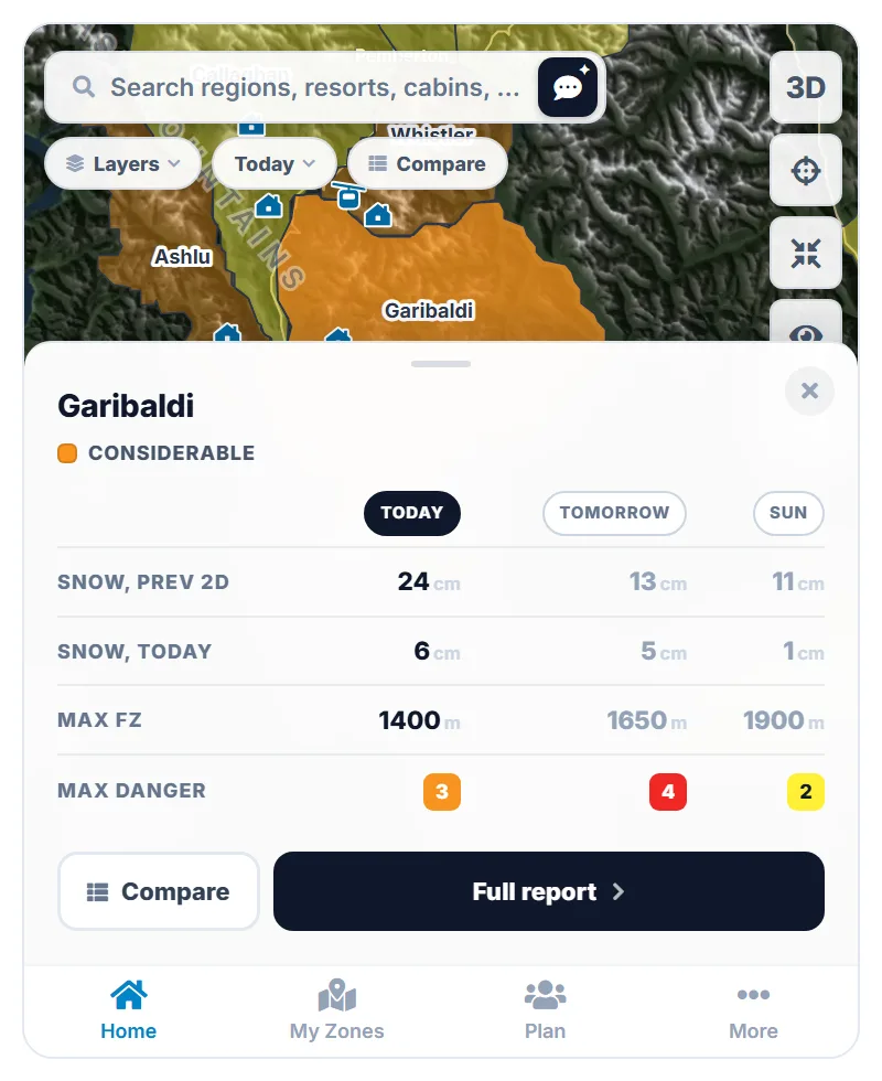
Tap Full report. The Avy tab opens on Avalanche Canada's bulletin itself: three days of danger ratings by elevation band, with arrows for anything that changed since the previous bulletin, then each avalanche problem by likelihood, size, elevation and aspect.
Garibaldi's grid tells the story. Considerable in the alpine and at treeline today, both up since Thursday, and High in the alpine on Saturday. Below it are two problems: a new wind slab from the strong southwest wind, and a persistent slab on surface hoar buried on February 8, now 35 to 40 cm down on shaded slopes and flagged as more likely and larger than yesterday.

Notice which day this bulletin is for. Avalanche Canada publishes its forecasts at about 4 PM Pacific for the next day, so the bulletin you read on Friday morning is Friday's. Its Saturday column is an outlook. Saturday's own bulletin comes out this afternoon, and that's the one to plan with.
The danger scale
Travel advice from the North American Public Avalanche Danger Scale, as Avalanche Canada uses it.
- Low (1): Generally safe avalanche conditions. Watch for unstable snow on isolated terrain features.
- Moderate (2): Heightened avalanche conditions on specific terrain features. Evaluate snow and terrain carefully; identify features of concern.
- Considerable (3): Dangerous avalanche conditions. Careful snowpack evaluation, cautious route-finding and conservative decision-making essential.
- High (4): Very dangerous avalanche conditions. Travel in avalanche terrain not recommended.
- Extreme (5): Avoid all avalanche terrain.
Two Considerable days can look nothing alike: one with a problem confined to a single aspect and elevation, one with problems everywhere. The problems are where you find out which one you're in.
Step 3: See What Every Source Says About the Same Layer
The bulletin names the Feb 8 surface hoar. The next question is whether anything else agrees. Switch the Avy tab to At a glance and the bulletin is read alongside the field reports and Snow Doctor's simulated snowpack, layer by layer, each line tagged by its source:
- Bulletin: 35 to 40 cm down on shaded slopes.
- Field: whumpfing on the approach to Elfin Lakes, Feb 12.
- Simulated: about 40 cm down at 1900 m on north, east and west, with a sun crust on south instead.
Under that: where the sources agree and differ, a confidence score, and a day-out checklist. When three sources built three different ways point at the same layer, that's worth knowing.
For the full write-up, Doctor's Orders reads the same sources and the weather at the region's three heights, and writes one report in seven sections: in short, the weather, the snowpack, avalanches, what people are seeing, where the best snow likely is, and what to watch for and test before you head out. Every report is timestamped, so you know how current it is.

If something surprises you, the source material is one tap away: the Weather tab's tables and charts at three heights, with five weather models for a second opinion, and the Snowpack tab's simulated pit. It's simulated, not observed, so use it to know what to look for. (How we simulate the snowpack.)
A note on AI: Doctor's Orders describes conditions. It can't see the snowpack, and it doesn't know your group. It never tells you whether to go.
Step 4: Check What People Saw
The Obs tab puts Mountain Information Network reports from within 50 km of the region on a map, marked red where someone saw an avalanche or an incident. This morning there are two red pins. One is on the Wedge Glacier: a size 2 slab that ran naturally overnight on a northeast lee slope, 40 cm deep, and a pit on the Feb 8 surface hoar 38 cm down.

That fits the bulletin's persistent slab, at the depth it gives, seen by someone on the snow. A report that confirms the bulletin builds confidence. One that contradicts it is worth sitting with.
You don't have to open every pin. A synthesized field report sums up what people are finding, how fresh and representative the reports are, and what terrain they're avoiding. The full reports are a tap away.
Step 5: Bring It Down to Your Own Terrain
The map and the compare table did the coarse search, from every region in BC down to two. The fine search happens on the slopes you'd actually ride. Regions are big; the day happens on a few slopes. In My Zones you save the spots you actually ride, each with its elevation band, main aspects and ATES terrain rating. Each one gets its own forecast, and its own simulated snowpack at its elevation and slope angle.
Open your Red Heather zone and its Avy tab marks the wind slab problem Matches this zone: the bulletin lists it at treeline, on the northerly aspects Red Heather faces. Weighing a spot you haven't saved? Drop a pin anywhere for that spot's own forecast, with ATES terrain, contours and 3D to judge the slope.
At lunch, Maya starts a plan for Saturday and sends the group the link. Everyone proposes from their own saved zones. Maya puts up Cerise Creek Bowl in the Duffey, Sam puts up Rohr Ridge beside it, and you put up Red Heather. The notes fill up with what each person found: Maya on how little snow the Duffey got, Sam on a field report of whumpfing near Rohr.
Step 6: Re-read When Saturday's Bulletin Lands
Saturday's bulletin comes out at about 4 PM. Snow Doctor checks a few minutes after each forecast centre publishes, and Doctor's Orders is rewritten from it, so the evening's report reads Saturday's bulletin, not the morning's. The arrows in the danger grid now show what moved since Friday's.
Reading it raises two questions, so you ask them. Ask the Doctor reads what the report was written from, the weather hour by hour for today and tomorrow, and your saved zones in the region.
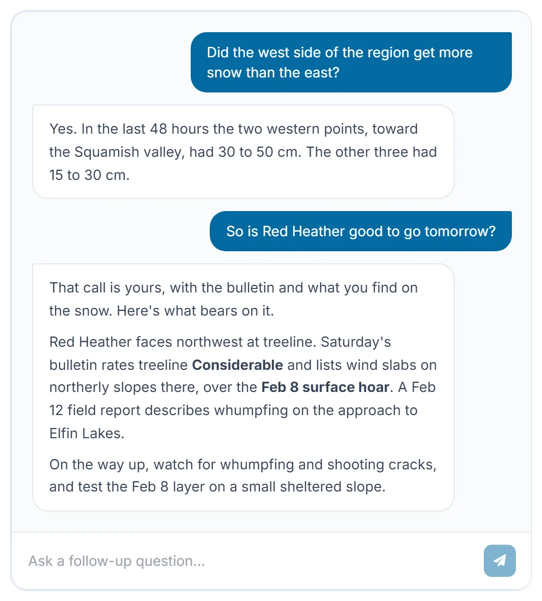
The first answer comes from the same five weather points as the snow map. The second is the guardrail at work: Ask the Doctor won't call a slope safe, tell you whether to go, or pick a zone for you. Ask anyway and you get the facts that bear on it, and what to check on the ground.
Step 7: Decide Together
By evening everyone has read the same reports. Each person ranks the options privately, and the plan sorts by the whole group's ranking. Everyone sees each option's average rank and how many people voted, but nobody sees who ranked what, so the plan reflects the group and not whoever is loudest in the chat.

Cerise Creek Bowl comes out on top. The checklist covers who's bringing what, and the last note settles the logistics: the Duffey is plowed, meet at the Cayoosh pullout at 7.
Snow Doctor didn't make that call. The crew did, with the same facts in front of everyone.
Step 8: Listen on the Drive
Before you leave, check whether anything changed overnight; Doctor's Orders carries its timestamp. Then tap Listen and Snow Doctor reads the Duffey's report aloud, chapter by chapter, at the speed you pick. The whole car hears the same brief, and nobody stares at a phone in the dark.

The day-out checklist from At a glance comes along: what to watch for, what to test, and travel habits. Arriving at the trailhead with the conditions already loaded beats improvising on the skin track.
Step 9: Close the Loop
What you saw out there is the best data of the day. Post a report to the Mountain Information Network: it helps the forecasters and the next party, and it shows up in Snow Doctor's field reports for the region, where someone planning Sunday will find it.
Later, pick a past date in the report, up to 30 days back, to see what the bulletin, weather and field reports said that day, and compare it with what you found.
Check Your Region Today
Wherever you're based (Squamish, Revelstoke, Golden, Nelson), there are regions nearby with conditions worth knowing. The map, the reports, your zones and your crew's plans are all in one place.
Open Snow DoctorMap relief from SRTM and NRCan CDEM via Terrain Tiles. Contains information licensed under the Open Government Licence – Canada. Lakes, glaciers and roads © OpenStreetMap contributors.